Guiding you through the Karst Features of the Driftless Area
Jo Daviess County Discovery Area
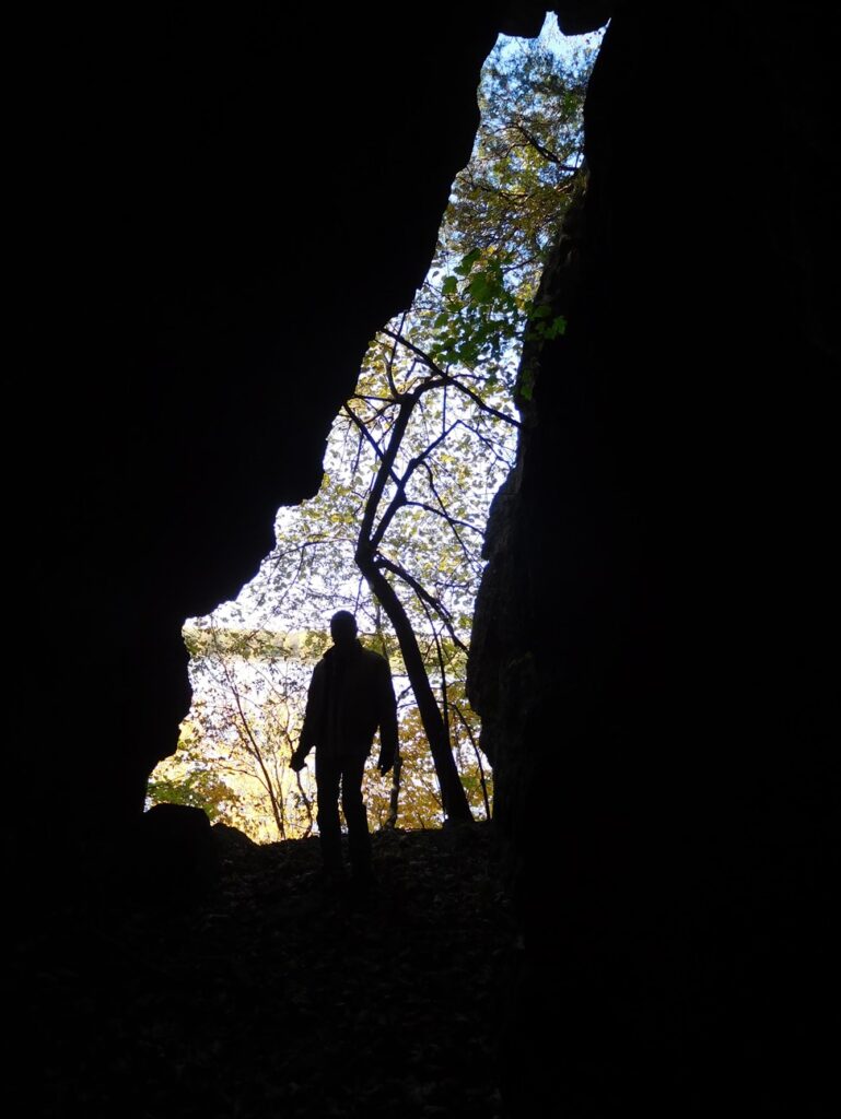
Apple River Canyon State Park
8763 E. Canyon Rd., Apple River, IL, 61001
Coordinates: 42.44676149369379° N, -90.05288347395751° W
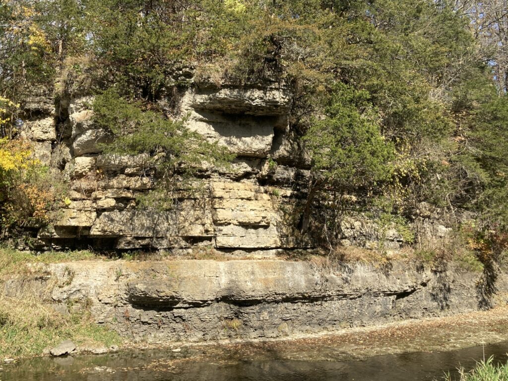
Located east of the Village of Apple River, Illinois, the 297-acre Apple River Canyon State Park has trails allowing exploration of the Apple River Canyon area and also provides amenities for picnicking and camping. Limestone bluffs, deep ravines, springs, streams and wildlife characterize this area. Once a part of a vast sea bottom that stretched from the Alleghenies to the Rockies, the scenic canyon area was formed by the action of the winding waters of the Apple River. Flowing for countless centuries, the Apple River has cute through limestone, dolomite, and shale deposits carving the canyon and creating massive cliffs rising high above the water. Five trails – Pine Ridge, Tower Rock, River Route, Sunset and Primrose Trail (accessible) – wind through the woods for several miles within the park.
Any fees?:Park amenity fees may apply
Accessible?:Primrose Trail – Yes, Others – No
Maintained by: Illinois Department of Natural Resources
Coordinates: 42.40448355883025° N, -90.39522808153039° W
Horseshoe Mound Preserve, located just outside of the City of Galena, is owned and managed by the Jo Daviess Conservation Foundation and is open to the public. The Mound is a U-shaped dolomite-mantled knob that provides one of the highest elevations in the area. Amenities include hiking trails, a central gathering area, viewing scopes, and scenic outlooks offering panoramic views that encompass high points in Iowa and Wisconsin. The knobs and ridges in the area are erosional remnants. The resistant Silurian dolomite cap rock provides some protection from erosion. However, the Silurian dolomite is highly fractured and is subject to dissolution and karst-forming processes that has dissolved and cleaved the cap rock into discrete blocks. Undercutting of the softer, more easily erodible Maquoketa Shale on which the dolomite rests results in metastable highlands with fractured, but relatively intact dolomite caps in some areas. In other areas, inherently unstable highlands are made up of large scattered and tilted blocks of dolomite that are collapsing and actively sliding down the slippery shale slopes. The Maquoketa Shale and underlying dolomite of the Galena Group make up the more subdued hills and the valleys of the area. The entrance to the Horseshoe Mound Preserve comes off of Blackjack Road and is well-marked.
Any fees?:No, it’s free!
Accessible?:Yes
Dog Friendly?:Yes
Maintained by: Jo Daviess Conservation Foundation
More Info:
http://jdcf.org/properties/horseshoe-mound/
River Road Galena River Trail
River Road south of Galena, Rice Township, IL
Coordinates: 42.56067777776048° N, -90.3772069024445° W
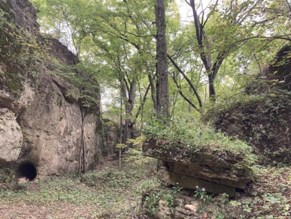
Crevices, mine openings
Maintained by: Private Owners
Sinkhole by Chestnut Mountain Resort
Hanover, IL, 61036
Sinkhole, Mississippi River view, possibly on private property but viewable from road ROW
Former “Elizabeth Tower” Site
Highway 20, near former Elizabeth Tower, IL
Rock cut with crevices and bedding planes
Maintained by: Illinois Department of Transportation
Spirit Rock
S. Rodden Rd., Elizabeth area, IL
Silurian blocks, tube caves
Maintained by: Private Owner
Galena, Illinois
Galena, IL
Coordinates: 42.421620513172165° N, -90.43123265483425° W
City has a history of mining/ore deposits.
Maintained by: City of Galena
Galena River Trail
211 S Bench St, Galena, IL, 61036
From U.S. Rte 20 turn north on Park Avenue; after a short distance, take the first left into the parking area.
Coordinates: 42.2437° N, -90.2548° W
Accessed from the Depot Parking Lot in downtown Galena, the City-owned Galena River Trail offers 8.0 miles (one way) of scenic hiking, biking, or cross-country skiing for users. Portions of the trail run alongside the Galena River and the Mississippi River to the east, with stretches of rock bluffs and outcroppings to the west. Crevices and historic mining adits in the rock faces can be seen along parts of the trail. Trail users should only view the features from the trail for safety reasons and to prevent trespass on private property. The lead-zinc ore deposits of the Driftless Area, which includes Jo Daviess County, were emplaced within the Galena Dolomite 270 million years ago. Ore-forming and associated solutions (hot brines) migrated through carbonate rocks along existing fractures and were responsible for enlarging many of these fractures into crevices. The crevices and infilling sulfide ore deposits created by these solutions have the same distribution and orientation as bedrock fractures identified using remote sensing techniques. Consequently, maps of mines and mining activities reflect the fracture and crevice orientations and provide additional information about the physical characteristics of the bedrock and karst aquifers of the Driftless Area.
Coordinates: 42.41551200878319° N, -90.43035302610798° W
Has exhibit on mining.
Maintained by: Nonprofit
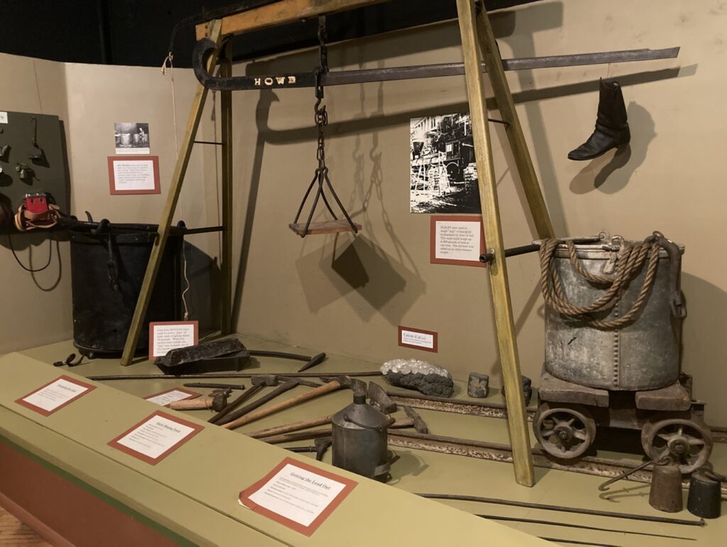
Galena & U.S. Grant Museum
211 S Bench St, Galena, IL, 61036
Coordinates: 42.245601° N, -90.254930° W
Located in downtown Galena, Illinois, the Galena History Museum offers permanent exhibits providing opportunities to learn more about the Driftless Area and the mining activities in the karst terrain of northwest Illinois. The interactive “Driftless Area & First Peoples” exhibit tells the story of the landscape and the Native Americans who first lived, hunted and mined Galena and the Driftless. The “Lead mining in the Northwest Region” exhibit tells the story of lead mining around Galena and the tri-state area and includes an original 1830s lead mine shaft. The lead-zinc ore deposits of the Driftless Area, which includes Jo Daviess County, were emplaced within the Galena Dolomite 270 million years ago. Ore-forming and associated solutions (hot brines) migrated through carbonate rocks along existing fractures and were responsible for enlarging many of these fractures into crevices. The crevices and infilling sulfide ore deposits created by these solutions have the same distribution and orientation as bedrock fractures identified using remote sensing techniques. Consequently, mines and mining activities reflect the fracture and crevice orientations and provide additional information about the physical characteristics of the bedrock and karst aquifers of the Driftless Area.
Coordinates: 42.23059524667678° N, -90.2908942814874° W
There are quarries in the area, but they are not public.
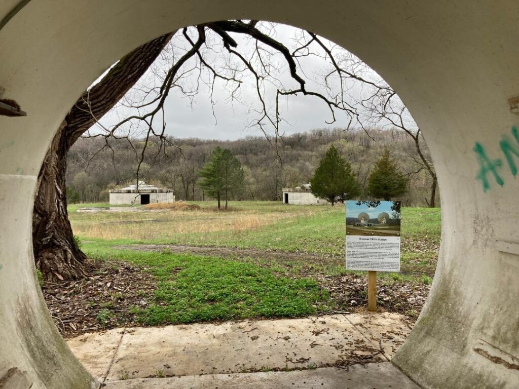
Hanover Earth Station Lookout
Hanover Earth Station was one of seven “earth stations” constructed in the 1970s by AT&T and GTE using technology developed by Bell Labs. Within 98-foot diameter antenna, these earth stations transmitted data to/from satellites 22,000 miles above the equator as part of the first communications satellite system for regular long-distance telephone calls in the U.S. Today, only the two massive concrete structures that had supported a 400-ton antenna and tracking system remain. The site sits at the end of a ridge and offers a panoramic view of adjacent ridges and the valley below. The large-scale erosional processes of this karst landscape are apparent in the view.
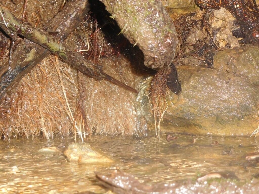
In order to support science-based water resource management in Jo Daviess County, Illinois, a systematic effort was undertaken to characterize the nature and function of the hydrogeology of the area and included the collecting and analyzing water samples from springs throughout the county, including the Witkowsky spring. At the sub-watershed level, Witkowsky Spring is located within the 128 square mile 12-digit hydrologic unit code (HUC 12) 070600050406 (Crooked Slough-Mississippi River) and, more broadly, within the Apple-Plum sub-basin of the Upper Mississippi River Basin. The spring area bedrock is dominated by Galena Dolomite. Witkowsky Spring discharges clear spring water from the base of a small tree where the tree roots have formed a small cave-like space whose groundwater flowed at a rate of about 10 gallons per minute (gpm). When sampled in July of 2019, Calcium and Magnesium concentrations of the spring water were found to be consistent with a dolomite aquifer. The relatively low Chloride (6.21 mg/L), Nitrate-Nitrogen (1.54 mg/L) and low microbial concentrations reflect the likely recharge area that is dominated by wooded terrain.