

Forestville/Mystery Cave State Park
21071 County Rd 118, Preston, MN, 55965
Follow County Rd 118/Kestrel Rd past the Park Office to reach the Maple Springs Campground.
Coordinates: 43.62939281899028° N, -92.23195113797253° W
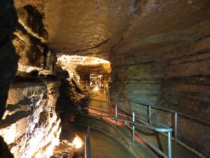
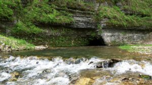
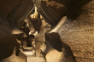
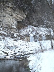
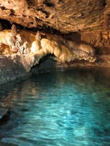
Discovered in 1937, Mystery Cave is the longest cave in Minnesota – spanning over 13 miles underground. It is a network of passages that was dissolved by moving water where visitors can see stalactites, stalagmites, flowstone, and beautiful underground pools. Mystery Cave is located in Forestville/Mystery Cave State Park. Visitors can explore the William H. Morrissey Visitor Center to learn about the Driftless Area and Mystery Cave. A variety of guided tours are offered daily in the summer and include modern lighting and paved walkways that enhance accessibility to more rustic lantern and wild cave tours.
Any fees?: Yes & State Park vehicle passes are required
Accessible?: Yes; Scenic or Photography Tours
Dog Friendly?: No
Time to Complete: 1 hour (for most tours), Longer for Geology & Wild Tours
Distance: 1/2 Mile (for most tours), Longer for Geology & Wild Tours
Managed by: The Minnesota Department of Natural Resources
More Info:
https://www.dnr.state.mn.us/mystery_cave/tour_map.html
https://reservemn.usedirect.com/MinnesotaWeb/Activities/programsandtours.aspx
Big Spring Trail Hike – Forestville/Mystery Cave State Park
21071 County Rd 118, Preston, MN, 55965
Follow County Rd 118/Kestrel Rd. Follow the signs at the Park Office to reach the Big Spring Trailhead.
Coordinates: 43.62939281899028° N, -92.23195113797253° W
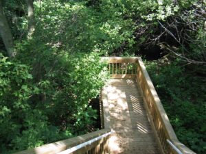
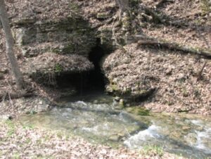
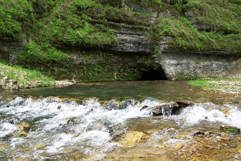
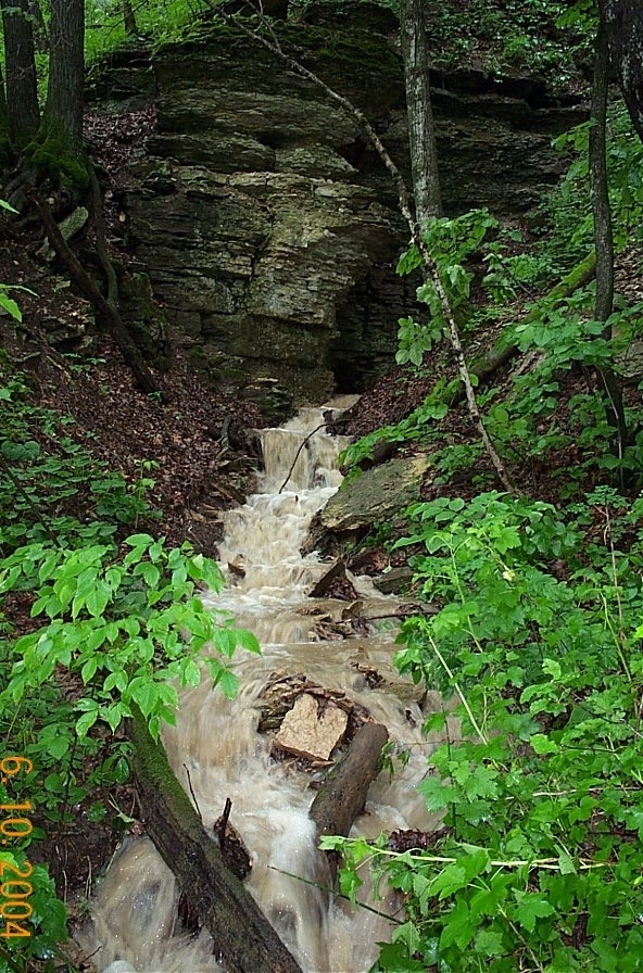
The Big Spring trail takes the hiker through a rugged wooded landscape, along steep limestone bluffs and cool trout streams. The trail begins with views of the South Branch Root River below. Reaching the valley bottom, Big Spring trail crosses a scenic bridge over the river. The trail eventually follows Canfield Creek before ending at Big Spring. The waters gushing from the mouth of Big Spring originate from Goliath’s Cave in Cherry Grove Blind Valley Scientific and Natural Area five miles away. As water travels underground, it is cooled by the rock to about 48 degrees. The cold water emerging from this and other springs create excellent habitat for cold water loving trout who require cold temperatures to survive. The adjacent cool algific slopes provide the perfect habitat for the rare Pleistocene land snail.
Any fees?: Yes & State Park vehicle passes are required
Accessible?: No
Dog Friendly?: Yes
Time to Complete: 2 hours
Difficulty: Moderate
Managed by: The Minnesota Department of Natural Resources
More Info:
https://files.dnr.state.mn.us/maps/state_parks/spk00148.pdf
https://www.dnr.state.mn.us/state_parks/virtual_tour/forestville_mystery_cave/dialup.html
https://www.dnr.state.mn.us/eco/nongame/projects/research_reports/abstracts/snails/ostlie1990.html
https://www.youtube.com/watch?v=A_zpHUH76wg
https://www.youtube.com/watch?v=oHP4h1gEcg4
Cherry Grove Blind Valley SNA
193rd St., Spring Valley, MN, 55975
This location pulls off from 193rd St and leads into a small parking lot.
Coordinates: 43.582067006389494° N, -92.2642834927758° W
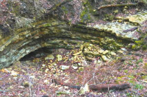
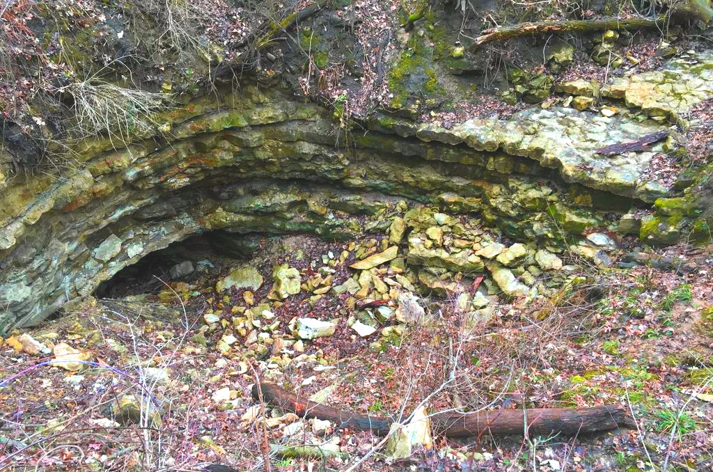
From the parking lot follow the mowed path and interpretive signs within the SNA. Here you will find the land pitted by sinkholes and crossed by stream channels that abruptly end, known as “blind valleys.” A small stream called Jessie’s Kill flows into the site, gradually loses water, and then disappears. Except on rare occasions, surface water that enters this site doesn’t exit—at least, not above ground. Waters from this blind valley flow underground and emerge at Big Spring in Forestville/Mystery Cave State Park. All are clues to a Karst landscape and this site’s most outstanding feature, Goliath Cave (originally named Coon Cave). The cave’s natural entry is gated at the base of a sinkhole depression, walled by bands of limestone and shale. From this point, the multi-level, multi-branched cave system extends eastward far beyond the SNA boundaries.
Any fees?: No, it’s free!
Accessible?: No
Dog Friendly?: No
Time to Complete: 45 minutes
Distance: 3/4 Mile (roundtrip)
Difficulty: Easy
Maintained by: The Minnesota Department of Natural Resources
More Info:
https://www.dnr.state.mn.us/snas/detail.html?id=sna02022
https://www.dnr.state.mn.us/waters/groundwater_section/mapping/springs.html
Fountain Big Spring
27513 Keeper Rd., Fountain, MN, 55935
Heading Northwest on Keeper Road, the entrance is a sharp turn to the right just as you approach 27513 Keeper Road, Fountain, MN, 55935.
Coordinates: 43.753783° N, -92.146162° W
About a mile northwest of Fountain near 27513 Keeper Rd., Fountain, MN 55935 is Fountain Big Spring, the largest of a complex of four springs. Many of the sinkholes in and around the town of Fountain drain to this spring complex within a time-scale of hours. This spring drains the sinkhole at Fountain Sinkhole kiosk and used to act as the city’s water supply. All four springs emerge near the base of the Cummingsville Formation in the Galena Group just above the Decorah Shale. These are typical conduit springs. Their flow often increases by an order of magnitude within a couple of hours after a rainfall and the springs become very sediment laden. Springs can become plugged by colluvium or debris or the spring can develop a new lower elevation outlet, either naturally or through human intervention. Fountain Big Spring has moved in the not too distant past. The previous outlet is a few feet down the valley and is now acting as a high flow overflow spring. That this was the main spring outlet for a long period and is evident from the size of the notch or “steep head” that was eroded into the valley wall by the old, higher spring outlet. Construction of the road down the ravine may have caused the new opening of the spring to form.
Any fees?: No, it’s free! (Self-guided)
Accessible?: Yes
Dog Friendly?: Yes
Time to Complete: 15 minutes
Distance: 0 Miles (View from the side of the road)
Difficulty: Very Easy
Fountain Sinkhole Kiosk
27513 Keeper Rd., Fountain, MN, 55935
Heading Northwest on Keeper Road, the entrance is a sharp turn to the right just as you approach 27513 Keeper Road, Fountain, MN, 55935
Coordinates: 43.753783° N, -92.146162° W
Walk on the paved Root River State Trail (which is built on an abandoned railroad right-of-way) 0.4 miles to a sinkhole where the Minnesota Department of Natural Resources–Parks and Trails Division installed a karst educational display. A wood walkway leads to a platform in the sinkhole where you can see the swallow hole; where water is diverted underground. The first bedrock here is Prosser Formation limestone of the middle Ordovician Galena Group. This area is representative of the high-density sinkhole plains that occur on broad ridge tops underlain by the Prosser limestone or Stewartville limestone of the Galena in southeastern Minnesota and northeastern Iowa. This is the northern end of a broad arc of Galena that runs from southeast Minnesota through Iowa into Wisconsin and Illinois.
As part of the display design, a dye trace was conducted from this sinkhole. Liquid fluorescein (206 gm.) was poured into the sinkhole’s swallow hole and was flushed with 4500 liters of water from a fire truck. The dye was detected at the Fountain Big Spring which lies to the northwest. Breakthrough flow velocity was 1-2 miles per day. The area around Fountain is in the groundwater springshed which feeds the Fountain Big Spring and three other smaller springs that are associated with it.
Any fees?: No, it’s free!
Accessible?: Yes
Dog Friendly?: Yes
Time to Complete: 1 hour
Distance: 0.8 Mile (roundtrip)
Difficulty: Easy
Maintained by: The Minnesota Department of Natural Resources
More Info:
Lanesboro DNR Fish Hatchery
23789 Grosbeak Road. Lanesboro, MN, 55949
Coordinates: 43.69974075554175° N, -91.99398877233862° W
The Lanesboro DNR Fish Hatchery works to manage trout populations in regional trout streams, as well as improving trout habitat quality, stream access, and monitoring. The site of the hatchery also includes an interpretive trail where visitors can learn about trout populations and habitat. Two artesian springs provide an average of 5,000 gallons of water per minute to the hatchery. The temperature of water emerging from the springs is a nearly constant 48F year round, and only minimally fluctuates following large rainfall or snowmelt events. The springs are a result of the karst topography in the area. The karst topography is a part of the Driftless Area of southeast Minnesota. The karst hydrology of the springs was evident when they would turn muddy after rain or snowmelt events. A stream sink was identified in an intermittent branch of Duschee Creek about 2 1/3 miles from the hatchery. Dye tracing proved its connection to the hatchery springs. The stream sink was sealed and the intermittent branch channel was diverted. The result was clean spring water for the hatchery’s fish. Please call the office or check the website for visitor hours.
Any fees?: No, it’s free!
Accessible?: Yes (in certain areas)
Dog Friendly?: No
Difficulty: Easy
Maintained by: The Minnesota Department of Natural Resources
More Info:
https://www.dnr.state.mn.us/areas/fisheries/lanesboro-hatchery/index.html

Niagara Cave
29842 County Hwy. 30, Harmony, MN, 55939
Coordinates: 43.51416681607232° N, -92.0551173431298° W
Located near Harmony, MN, Niagara Cave was discovered in 1924 and first opened for tours in 1934. Niagara Cave is privately owned and one of only two publicly accessible caves in Minnesota. Niagara Cave is an unusual upper Mississippi Valley cave. Most of the large caves in the southeast Minnesota/northeast Iowa karst are maze caves developed near the Galena/Dubuque contact (Mystery Cave, for example). Niagara’s entrance is a sinkhole through the Dubuque Formation. The cave cuts down through the Stewartville Formation in several dome pits and vadose canyons to a stream passage in the Prosser Formation. Niagara Cave contains the best, most accessible example of a cave stream, active vadose canyon, and waterfall of any cave in the area.
Accessible?: No
Dog Friendly?: Yes (on the grounds), No (in the cave)
Time to Complete: 1 Hour
Distance: 1 Mile and 275 Steps
Difficulty: Moderate/Strenuous
Maintained by: Private owner
More Info:

Harmony Visitor Center/Sinkhole Kiosk
15 22nd St NW, Harmony, MN, 55939
Coordinates: 43.55590305364476° N, -92.01045064203859° W
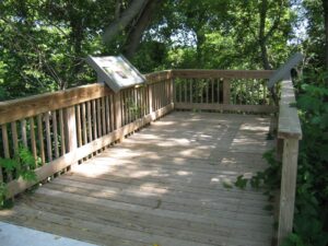
The Harmony Visitor Center is open to the public from April through October. Inside the visitor center explore exhibits about karst and see fossils from the Ordovician Period. A short hike on the Harmony-Preston Valley State Trail, which starts right behind the visitor center, leads to the Harmony Karst Interpretive Site. The sinkhole, highlighted at the site, is a good example of the unique geological make-up of southeastern Minnesota. Three drainage holes are featured as a point of interest with a viewing deck located above them. There are also several educational signs located throughout the sinkhole, explaining the geology of the sinkhole, how it was formed and why it is important to protect sinkholes and keep them clean.
Any fees?: No, it’s free!
Accessible?: Yes
Dog Friendly?: Yes (on the trail), No (in the Visitor Center)
Time to Complete: 1 hour
Distance: 1.2 Miles (roundtrip)
Difficulty: Easy
More Info:
Historic Bluff Country Scenic Byway
Route: Hwy. 16 between La Crescent and Dexter, small loop on US-52 and MN-80 also connects Wykoff and Fountain; a scenic alternative to I-90.
Explore the Karst topography of the Driftless Area by vehicle or bicycle. This 88 mile national scenic byway follows the Root River through deeply carved valleys dominated by towering limestone cliffs. Travel the byway to the Lanesboro Fish Hatchery and other locations within the Discovery Areas.
Any fees?: No, it’s free!
Accessible?: Yes (by car)
Dog Friendly?: Yes
Time to Complete: 4-8 hours
Distance: 88 Miles
More Info:
https://www.dnr.state.mn.us/state_parks/park.html?id=spk00160#homepage