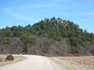


Castle Rock State Natural Area
From Lincoln Ave (US-18 E/US-61 S) in Fennimore go for 0.7 mi on 18. Turn left onto CR-Q and continue for approximately 8.9 miles. Castle Rock will be on the right with a pullout for several cars to park. An interpretive sign is located at the trailhead.
Coordinates: 43.0444336° N, -90.5204033° W
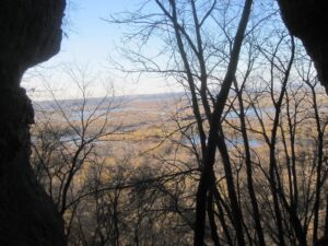
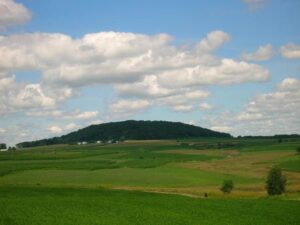
Castle Rock is visible from Hwy Q where you park just off the road to take the small dirt path up to the summit. This impressive geologic structure is composed primarily of sandstone. Its’ origins began sometime between 150 and 300 million years before present when Wisconsin was covered by a shallow sea. Deposited sediments compacting under their own weight developed the structure you see today.
Any fees?: No
Accessible?: No (Castle Rock can be seen from the road but the trail to the top is not accessible)
Dog Friendly?: Yes
More Info:
https://www.topozone.com/wisconsin/grant-wi/pillar/castle-rock-146/
Castle Rock Spring
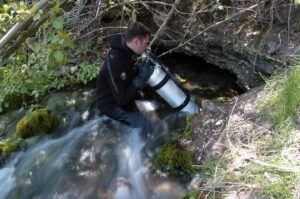
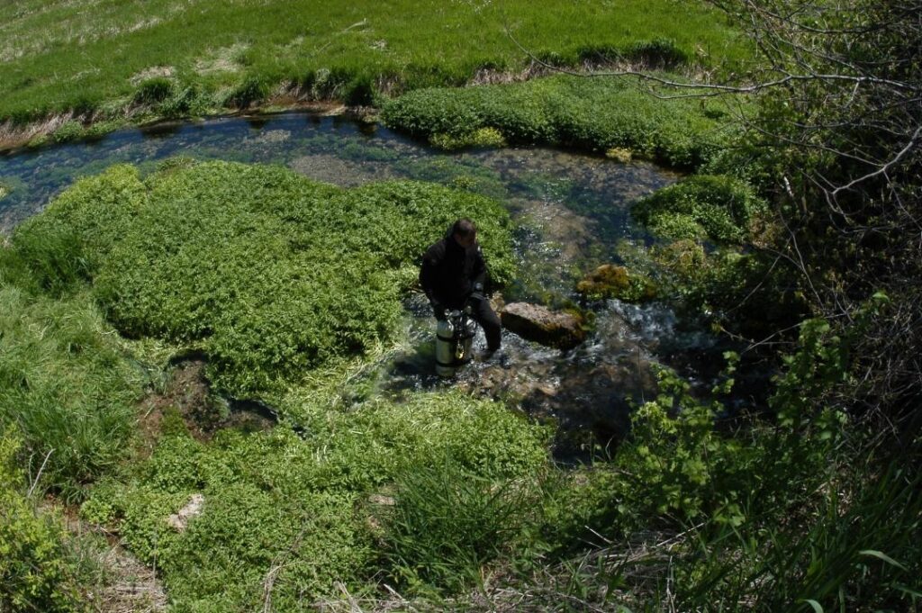
In the same area of the Castle Rock, Castle Rock Spring is located just north of Church Road on the right side of Cty Tk Q. Springs, a Driftless Area feature, provide the frigid water, ideal habitat for supporting trout. The river is a classic, cold water Driftless Area stream with a noteworthy trout fishery.
Any Fees?: No, it’s free!
Accessible?: No (Can be seen from the Road)
Dog Friendly?: Yes
Wyalusing State Park
Take U.S. 18 south from Prairie du Chien; turn right on County Highway C to County Highway X. Turn right on X and follow it to the park.
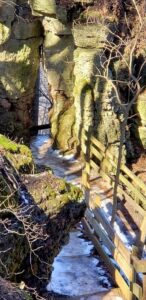
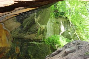
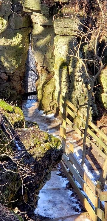
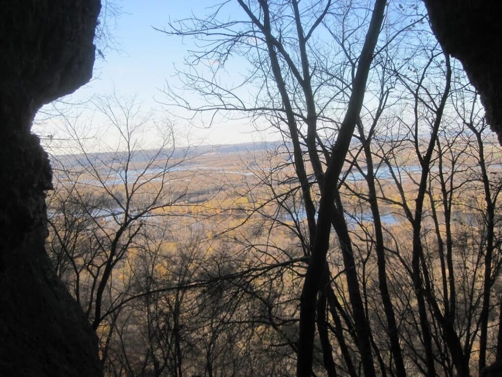
Situated above the confluence of the Wisconsin and Mississippi Rivers, the area that is now Wyalusing State Park was once a neutral ground where at least 14 Native American tribes lived or visited to trade. The 500-foot river bluffs have changed little since the tribes walked these lands. The openings of several small caves and rock shelters mark the bluffs, which are built of layers of dolomite, shale, and sandstone. The geologic sequence at Wyalusing is representative of the lower Ordovician carbonate/clastic sequence of the Driftless Area, from the contact with the underlying Jordan Sandstone at about river level through the Prairie du Chien dolostones up to the overlying St Peter Sandstone. Most of the karst is within the Prairie du Chien but is poorly exposed, bar a few small depressions and dry valleys. The caves are at the carbonate-sandstone contacts, Big and Little Sand Caves at the base and Pictured Rock at the top of the dolostones.
Any fees?: No (vehicle admission stickers are required)
Accessible?: Some scenery is accessible, many trails are not
Dog Friendly?: Yes
Time to Complete: 3/4 hour (to Small Cave from the park road), 1 hour (to Big Cave from Twin Valley Campground)
Distance: Less than 1 Mile – 2 Miles
Difficulty: Easy/Severe (Several trails are steep)
More Info:
http://dnr.wi.gov/topic/parks/name/wyalusing/
Bluff Trail
Take U.S. 18 south from Prairie du Chien; turn right on County Highway C to County Highway X. Turn right on X and follow it to the park.
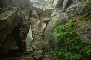
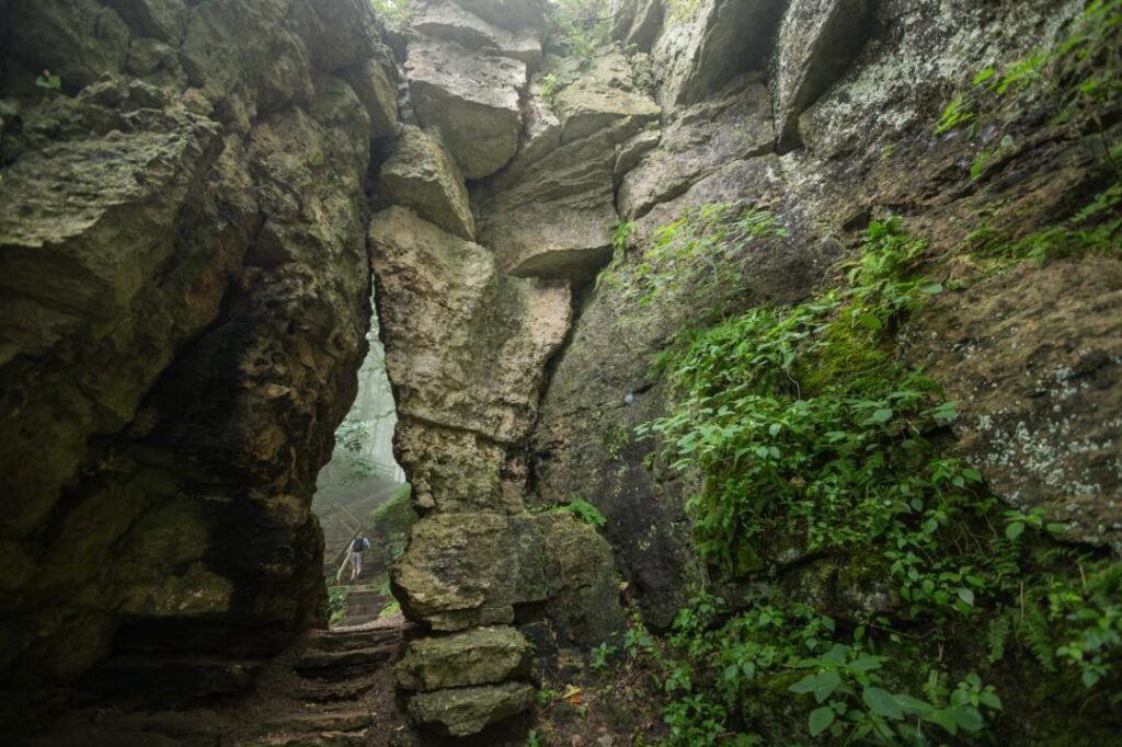
The hike to Treasure Cave begins at Point Lookout and heads down the Bluff Trail and through the keyhole—a narrow passage in a limestone outcrop. The small cave offers passage to a rock-framed window looking out on the Wisconsin River and two small rooms.
Any fees?: No (Vehicle Admission Sticker required)
Accessible?: No
Dog Friendly?: Yes
Distance: 0.9 Miles
Difficulty: Easy
More Info:
http://dnr.wi.gov/topic/parks/name/wyalusing/

Sand Cave Trail
Take U.S. 18 south from Prairie du Chien; turn right on County Highway C to County Highway X. Turn right on X and follow it to the park.
Big Sand Cave, Little Sand Cave, and Pictured Rock Cave are sandstone rock shelters . Little Sand Cave and Pictured Rock Cave feature small waterfalls that feed streams at their base. Black Thunder Point, located between the two caves offers an excellent view of the Wisconsin River.
Accessible?: No
Dog Friendly?: Yes
Distance: 1.6 Miles
Difficulty: Easy/Moderate
More Info:
http://dnr.wi.gov/topic/parks/name/wyalusing/
Mississippi Ridge Trail
Take U.S. 18 south from Prairie du Chien; turn right on County Highway C to County Highway X. Turn right on X and follow it to the park.
Mississippi Ridge trail starts at Homestead Picnic Shelter (parking available), crosses Cathedral Tree Drive and runs parallel to it until Henneger Point Picnic Area. The trail follows the bluff along the Mississippi River, ending at Henneger Point Picnic Area. An excellent view of the Mississippi River is available from Henneger Point. Bicyclists are welcome to bike the return trip back to Homestead Picnic Shelter via Cathedral Tree Drive.
Any fees?: No (vehicle admission stickers are required)
Accessible?: No
Dog Friendly?: Yes
Distance: 1.8 Miles
Difficulty: Easy/Severe (Several trails are steep)
More Info:
Lower Wisconsin River Road – Scenic Byway 60
(From Ithaca) Take Highway 58 south 4 miles to Highway 14 south. Turn south (left) on Highway 14 for 6 miles to Scenic Byway 60 and turn right. At this point the Scenic Byway 60 follows the graceful curves of the Lower Wisconsin River.
From either Wyalusing State Park or Elephant Rock in Ithaca, Wisconsin, the Lower Wisconsin Scenic Byway connects the two sites but are separated by 62 miles of Driftless Area scenery.
Any fees?: No, it’s free!
Accessible?: Yes
Dog Friendly?: Yes
More Info:
https://sites.google.com/site/lowerwisconsinriverroad/
https://www.facebook.com/Scenic60
http://www.scenic60.com

Belmont Mound State Park
Belmont Mound State Park, N Co Rd G, Platteville, WI 53818
Belmont Mound is one of several Driftless Area remnants that retain a top geologic layer of Niagara dolomite (limestone), along with Blue and Platte mounds. This dolomite formed during the Silurian Period some 430 million years ago. Beneath the Niagara dolomite lay bands of shale, limestone, and sandstone formed during the Ordovician Period some 470 million years ago; below these layers are blankets dating to the Cambrian and pre-Cambrian periods more than 500 million years ago. At the bottom is granite bedrock. The sandstones and limestones were deposited as inland seas covered and retreated from this region over the millennia. During the last 400 million years, erosion has carved this area, removing most rock layers, except for these mound remnants, still capped with the hard Niagara dolomite. The Niagara dolomite extends along the escarpment in eastern Wisconsin northeast to Niagara Falls. Formations on the north slope of the mound include a 40-foot-wide “tabletop,” about 40 feet across and a “cave” passage through a large boulder. There is an old limestone quarry on the south side of the mound and the remains of likely kilns near the parking area.
The trails go around the base of the mound, through the center of the park and to a loop in the northeast corner of the park. The trails are mostly for hiking, but off-road bikes may also use the trails. The observation tower is closed.
Any fees?: No (vehicle admission stickers are required)
Accessible?: Yes
Dog Friendly?: Yes
Distance: 1 Mile (roundtrip)
Time to Complete: 1/2 hour
Difficulty: Easy
More Info:

The Mining and Rollo Jamison Museum
405 East Main Street, P.O. Box 780 Platteville, WI 53818
Exhibits in the Mining Museum building trace the development of lead and zinc mining in the Upper Mississippi Valley Lead and Zinc District from its beginnings in the 1820s until active mining ceased in 1979. Through dioramas, photographs, maps, and artifacts you will learn how lead and zinc were mined and processed into useful items of everyday life.
Exhibits in the Rollo Jamison galleries explore the personal collection of Rollo Jamison. Rollo Jamison, born in Beetown, Wisconsin in 1899, started collecting arrowheads on his family’s farm. This was just the beginning of his life-long interest in history and the objects used by people in their everyday lives. Rollo’s collection grew over the years, representing the unique history of Southwest Wisconsin. Your tour will take you back to the turn of the 20th century for a look at what life was like in Platteville and southwest Wisconsin.
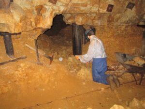
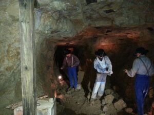
More than 150 years ago Lorenzo Bevans struck it rich just a few yards from the museum back door. As you walk down the 90-step incline into the 1845 Bevans Mine, your senses will be alive as the temperature and humidity levels change. A tour of the mine takes you through over 100 years of local lead and zinc mining history. A visit to the headframe shows how ore was hoisted to the surface and hand-sorted.
Any fees?: Yes (tour fees apply)
Accessible?: No
Dog Friendly?: No
More Info:
https://mining.jamison.museum/