If you would like to select a site directly and explore what else is in this state, please select a location marker above.
If you would like to explore what is in individual counties, please select your county of interest above.
Forestville/Mystery Cave State Park
21071 County Rd 118, Preston, MN, 55965
Follow County Rd 118/Kestrel Rd past the Park Office to reach the Maple Springs Campground.
Coordinates: 43.62939281899028° N, -92.23195113797253° W
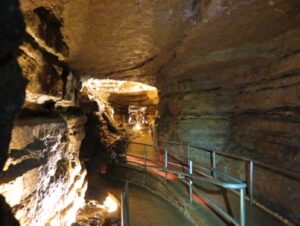
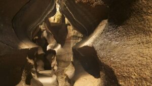
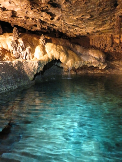
Discovered in 1937, Mystery Cave is the longest cave in Minnesota – spanning over 13 miles underground. It is a network of passages that was dissolved by moving water where visitors can see stalactites, stalagmites, flowstone, and beautiful underground pools. Mystery Cave is located in Forestville/Mystery Cave State Park. Visitors can explore the William H. Morrissey Visitor Center to learn about the Driftless Area and Mystery Cave. A variety of guided tours are offered daily in the summer and include modern lighting and paved walkways that enhance accessibility to more rustic lantern and wild cave tours.
Any fees?: Yes & State Park vehicle passes are required
Accessible?: Yes; Scenic or Photography Tours
Dog Friendly?: No
Time to Complete: 1 hour (for most tours), Longer for Geology & Wild Tours
Distance: 1/2 Mile (for most tours), Longer for Geology & Wild Tours
Managed by: The Minnesota Department of Natural Resources
More Info:
https://www.dnr.state.mn.us/mystery_cave/tour_map.html
https://reservemn.usedirect.com/MinnesotaWeb/Activities/programsandtours.aspx
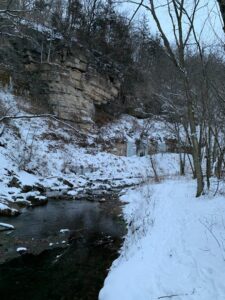
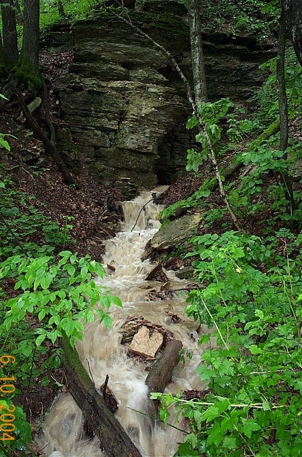
Big Spring Trail Hike – Forestville/Mystery Cave State Park
21071 County Rd 118, Preston, MN, 55965
Follow County Rd 118/Kestrel Rd. Follow the signs at the Park Office to reach the Big Spring Trailhead.
Coordinates: 43.62939281899028° N, -92.23195113797253° W
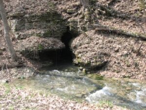
The Big Spring trail takes the hiker through a rugged wooded landscape, along steep limestone bluffs and cool trout streams. The trail begins with views of the South Branch Root River below. Reaching the valley bottom, Big Spring trail crosses a scenic bridge over the river. The trail eventually follows Canfield Creek before ending at Big Spring. The waters gushing from the mouth of Big Spring originate from Goliath’s Cave in Cherry Grove Blind Valley Scientific and Natural Area five miles away. As water travels underground, it is cooled by the rock to about 48 degrees. The cold water emerging from this and other springs create excellent habitat for cold water loving trout who require cold temperatures to survive. The adjacent cool algific slopes provide the perfect habitat for the rare Pleistocene land snail.
Any fees?: Yes & State Park vehicle passes are required
Accessible?: No
Dog Friendly?: Yes
Time to Complete: 2 hours
Difficulty: Moderate
Managed by: The Minnesota Department of Natural Resources
More Info:
https://files.dnr.state.mn.us/maps/state_parks/spk00148.pdf
https://www.dnr.state.mn.us/state_parks/virtual_tour/forestville_mystery_cave/dialup.html
https://www.dnr.state.mn.us/eco/nongame/projects/research_reports/abstracts/snails/ostlie1990.html
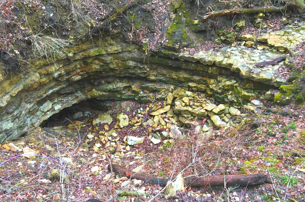
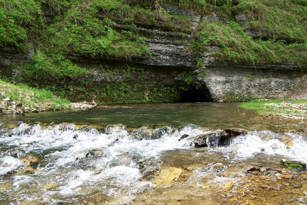
Cherry Grove Blind Valley SNA
193rd St., Spring Valley, MN, 55975
This location pulls off from 193rd St and leads into a small parking lot.
Coordinates: 43.582067006389494° N, -92.2642834927758° W
From the parking lot follow the mowed path and interpretive signs within the SNA. Here you will find the land pitted by sinkholes and crossed by stream channels that abruptly end, known as “blind valleys.” A small stream called Jessie’s Kill flows into the site, gradually loses water, and then disappears. Except on rare occasions, surface water that enters this site doesn’t exit—at least, not above ground. Waters from this blind valley flow underground and emerge at Big Spring in Forestville/Mystery Cave State Park. All are clues to a Karst landscape and this site’s most outstanding feature, Goliath Cave (originally named Coon Cave). The cave’s natural entry is gated at the base of a sinkhole depression, walled by bands of limestone and shale. From this point, the multi-level, multi-branched cave system extends eastward far beyond the SNA boundaries.
Any fees?: No, it’s free!
Accessible?: No
Dog Friendly?: No
Time to Complete: 45 minutes
Distance: 3/4 Mile (roundtrip)
Difficulty: Easy
Maintained by: The Minnesota Department of Natural Resources
More Info:
https://www.dnr.state.mn.us/snas/detail.html?id=sna02022
https://www.dnr.state.mn.us/waters/groundwater_section/mapping/springs.html
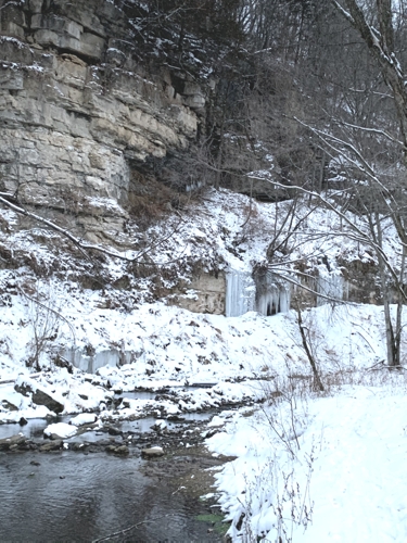
Fountain Big Spring
27513 Keeper Rd., Fountain, MN, 55935
Heading Northwest on Keeper Road, the entrance is a sharp turn to the right just as you approach 27513 Keeper Road, Fountain, MN, 55935.
Coordinates: 43.753783° N, -92.146162° W
About a mile northwest of Fountain near 27513 Keeper Rd., Fountain, MN 55935 is Fountain Big Spring, the largest of a complex of four springs. Many of the sinkholes in and around the town of Fountain drain to this spring complex within a time-scale of hours. This spring drains the sinkhole at Fountain Sinkhole kiosk and used to act as the city’s water supply. All four springs emerge near the base of the Cummingsville Formation in the Galena Group just above the Decorah Shale. These are typical conduit springs. Their flow often increases by an order of magnitude within a couple of hours after a rainfall and the springs become very sediment laden. Springs can become plugged by colluvium or debris or the spring can develop a new lower elevation outlet, either naturally or through human intervention. Fountain Big Spring has moved in the not too distant past. The previous outlet is a few feet down the valley and is now acting as a high flow overflow spring. That this was the main spring outlet for a long period and is evident from the size of the notch or “steep head” that was eroded into the valley wall by the old, higher spring outlet. Construction of the road down the ravine may have caused the new opening of the spring to form.
Any fees?: No, it’s free! (Self-guided)
Accessible?: Yes
Dog Friendly?: Yes
Time to Complete: 15 minutes
Distance: 0 Miles (View from the side of the road)
Difficulty: Very Easy
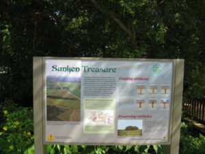
Fountain Sinkhole Kiosk
27513 Keeper Rd., Fountain, MN, 55935
Heading Northwest on Keeper Road, the entrance is a sharp turn to the right just as you approach 27513 Keeper Road, Fountain, MN, 55935
Coordinates: 43.753783° N, -92.146162° W
Walk on the paved Root River State Trail (which is built on an abandoned railroad right-of-way) 0.4 miles to a sinkhole where the Minnesota Department of Natural Resources–Parks and Trails Division installed a karst educational display. A wood walkway leads to a platform in the sinkhole where you can see the swallow hole; where water is diverted underground. The first bedrock here is Prosser Formation limestone of the middle Ordovician Galena Group. This area is representative of the high-density sinkhole plains that occur on broad ridge tops underlain by the Prosser limestone or Stewartville limestone of the Galena in southeastern Minnesota and northeastern Iowa. This is the northern end of a broad arc of Galena that runs from southeast Minnesota through Iowa into Wisconsin and Illinois.
As part of the display design, a dye trace was conducted from this sinkhole. Liquid fluorescein (206 gm.) was poured into the sinkhole’s swallow hole and was flushed with 4500 liters of water from a fire truck. The dye was detected at the Fountain Big Spring which lies to the northwest. Breakthrough flow velocity was 1-2 miles per day. The area around Fountain is in the groundwater springshed which feeds the Fountain Big Spring and three other smaller springs that are associated with it.
Any fees?: No, it’s free!
Accessible?: Yes
Dog Friendly?: Yes
Time to Complete: 1 hour
Distance: 0.8 Mile (roundtrip)
Difficulty: Easy
Maintained by: The Minnesota Department of Natural Resources
More Info:
Lanesboro DNR Fish Hatchery
23789 Grosbeak Road. Lanesboro, MN, 55949
Coordinates: 43.69974075554175° N, -91.99398877233862° W
The Lanesboro DNR Fish Hatchery works to manage trout populations in regional trout streams, as well as improving trout habitat quality, stream access, and monitoring. The site of the hatchery also includes an interpretive trail where visitors can learn about trout populations and habitat. Two artesian springs provide an average of 5,000 gallons of water per minute to the hatchery. The temperature of water emerging from the springs is a nearly constant 48F year round, and only minimally fluctuates following large rainfall or snowmelt events. The springs are a result of the karst topography in the area. The karst topography is a part of the Driftless Area of southeast Minnesota. The karst hydrology of the springs was evident when they would turn muddy after rain or snowmelt events. A stream sink was identified in an intermittent branch of Duschee Creek about 2 1/3 miles from the hatchery. Dye tracing proved its connection to the hatchery springs. The stream sink was sealed and the intermittent branch channel was diverted. The result was clean spring water for the hatchery’s fish. Please call the office or check the website for visitor hours.
Any fees?: No, it’s free!
Accessible?: Yes (in certain areas)
Dog Friendly?: No
Difficulty: Easy
Maintained by: The Minnesota Department of Natural Resources
More Info:
https://www.dnr.state.mn.us/areas/fisheries/lanesboro-hatchery/index.html

Niagara Cave
29842 County Hwy. 30, Harmony, MN, 55939
Coordinates: 43.51416681607232° N, -92.0551173431298° W
Located near Harmony, MN, Niagara Cave was discovered in 1924 and first opened for tours in 1934. Niagara Cave is privately owned and one of only two publicly accessible caves in Minnesota. Niagara Cave is an unusual upper Mississippi Valley cave. Most of the large caves in the southeast Minnesota/northeast Iowa karst are maze caves developed near the Galena/Dubuque contact (Mystery Cave, for example). Niagara’s entrance is a sinkhole through the Dubuque Formation. The cave cuts down through the Stewartville Formation in several dome pits and vadose canyons to a stream passage in the Prosser Formation. Niagara Cave contains the best, most accessible example of a cave stream, active vadose canyon, and waterfall of any cave in the area.
Accessible?: No
Dog Friendly?: Yes (on the grounds), No (in the cave)
Time to Complete: 1 Hour
Distance: 1 Mile and 275 Steps
Difficulty: Moderate/Strenuous
Maintained by: Private owner
More Info:
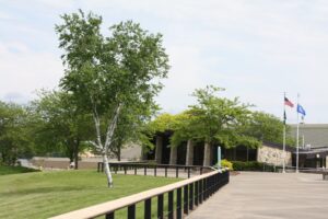
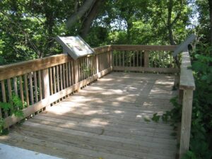
Harmony Visitor Center/Sinkhole Kiosk
15 22nd St NW, Harmony, MN, 55939
Coordinates: 43.55590305364476° N, -92.01045064203859° W
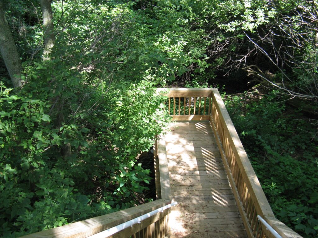
The Harmony Visitor Center is open to the public from April through October. Inside the visitor center explore exhibits about karst and see fossils from the Ordovician Period. A short hike on the Harmony-Preston Valley State Trail, which starts right behind the visitor center, leads to the Harmony Karst Interpretive Site. The sinkhole, highlighted at the site, is a good example of the unique geological make-up of southeastern Minnesota. Three drainage holes are featured as a point of interest with a viewing deck located above them. There are also several educational signs located throughout the sinkhole, explaining the geology of the sinkhole, how it was formed and why it is important to protect sinkholes and keep them clean.
Any fees?: No, it’s free!
Accessible?: Yes
Dog Friendly?: Yes (on the trail), No (in the Visitor Center)
Time to Complete: 1 hour
Distance: 1.2 Miles (roundtrip)
Difficulty: Easy
More Info:
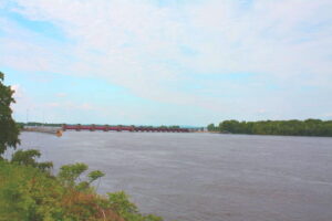
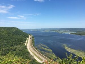
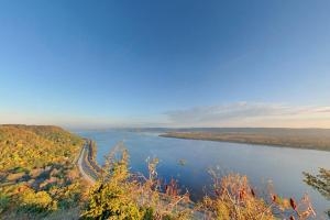
Dresbach Welcome Center
33020 Highway 61, La Crescent, MN, 55947
The entrance is a left off of River Access Road and the Welcome Center will be the first building to the right.
Coordinates: 43.8596061054827° N, -91.30443533148704° W
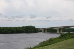
Overlooking lock and dam #7, Dresbach sits perched on the Mississippi River. The views seen here demonstrates the presence of a karst terrain adding to the geological interest of the area. The deep river valleys such as the Mississippi, sinkholes, caves and limestone bluffs are products of geological processes unique in the Midwest. The resulting topography provides a basis for all other resources and is the reason for the scenic and recreational opportunities of the region. This area is known as the Driftless Area, referring to the absence of glacial drift, or debris, from the Wisconsinian glacier which covered most of Minnesota and Wisconsin but did not extend to this area. Bluff Country rivers and streams represent older and more developed drainage systems than areas with more recent glaciations. This older topography has preserved Pre-Wisconsinian area not otherwise found in the region.
Any fees?: No, it’s free!
Accessible?: Yes
Dog Friendly?: Yes (leashed outside), No (in the Visitor Center)
Difficulty: Easy
More Info:
https://www.exploreminnesota.com/profile/dresbach-welcome-center/2073
Big Spring – Beaver Creek Valley State Park
15954 County Rd. 1, Caledonia, MN, 55921
The entrance is a parking lot on the right if heading West on County Road 1.
Coordinates: 43.64441777663155° N, -91.5808460145664° W
Big Spring, the source of Beaver Creek, became part of Beaver Creek Valley State Park in 1937. As slightly acidic water seeps into and follows fractures in the bedrock, it slowly dissolves the carbonate limestone rock and gradually enlarges the cracks. Continued erosion along these passageways develops a system of underground drainage that bypasses the surface drainage pattern. As a result, groundwater can move quickly to replenish an underground reservoir, and then, as is the case at Big Spring, escape through porous rock layers to finally emerge as a bubbling spring.
Any fees?: No, but a State Park vehicle permit is required.
Accessible?: No
Dog Friendly?: Yes
Time to Complete: 30 minutes
Distance: 1/2 Mile (roundtrip)
Difficulty: Easy
Maintained by: The Minnesota Department of Natural Resources
More Info:
https://www.dnr.state.mn.us/state_parks/park.html?id=spk00112#homepage
Chimney Rock – Whitewater State Park
19041 Highway 74, Altura, MN 55910
Coordinates: 44.06147387564574° N, -92.04708252353316° W
Chimney Rock provides a panoramic view of the valley while offering an ideal location for park naturalists to share about the unique geologic history of the park. The prominent cliffs are made mostly from the resistant Oneota Dolostone that underlies much of this area. The movement of mildly acidic groundwater has dissolved the bedrock and created a number of karst features that can be seen in the cliff faces. The Chimney Rock trail has the most accessible exposures of the 500-million-year-old bedrock in the park. The small hole at the base of the pinnacle is an example of the cavities through which ground water travels where the Oneota lies beneath the land surface. Across the valley toward the west side of the river you may see some caverns at the base of the bluffs. Some north facing caves in the blufflands contain ice year round because their openings receive no direct sunlight for most of the day, and they are insulated by surrounding rock from the warm outside air in the summer.
Any fees?: No, but a State Park vehicle permit is required
Accessible?: No
Dog Friendly?: Yes
Time to Complete: 45 minutes
Distance: 0.7 Mile (roundtrip), 220ft elevation gain
Difficulty: Difficult
Maintained by: The Minnesota Department of Natural Resources
More Info:
https://www.dnr.state.mn.us/state_parks/park.html?id=spk00280#homepage
http://files.dnr.state.mn.us/destinations/state_parks/virtual_tours/whitewater/vt_whitewater.html
https://conservancy.umn.edu/bitstream/handle/11299/57274/MGS_ES_9.pdf
Stream Sink – Whitewater Wildlife Management Area
Winona County Road 37, Altura, MN, 55910
Heading Southwest along County Road 37, the Stream Sink can be seen close to the road on the right after passing the MN Department of Natural Resources Crystal Springs Trout Hatchery.
Coordinates: 44.071052° N, -91.990742° W
Located in the Wildlife Management Area along Winona County Road 37, about a 1/8 mile southwest of the Crystal Springs Trout Hatchery, a spring-fed stream disappears underground through a series of sinking points in the rock layers below (Prairie du Chien through the St. Lawrence). Surface water in this region can sink quickly into the aquifer underground carrying pollutants to our drinking water and to springs such as the one that feeds the nearby trout hatchery. Hydrologists use dye-tracing to study the underground movement of water from sinking streams and sinkholes. The discovery of St. Lawrence stream sinks such as the one at this site that connect to conduits conveying water to springs, is a major achievement made by hydrologists in the last decade or so. Research is ongoing in an effort to better predict, detect and contain groundwater contamination caused by human activity.
This stream sink changes location depending on precipitation. You may have to walk upstream to observe the sink location during dry spells. Likewise, you may have to walk downstream to observe the sink location during wet spells. After snow melt or heavy rain events, the stream may not totally disappear at all.
Any fees?: No, it’s free!
Accessible?: No
Dog Friendly?: Yes
Time to Complete: 30 minutes
Distance: 500-2,500 ft
Difficulty: Easy (climbing up and out of stream bed will occur)
Maintained by: The Minnesota Department of Natural Resources
More Info:
https://www.dnr.state.mn.us/waters/groundwater_section/mapping/springs.html
https://conservancy.umn.edu/handle/11299/188688
https://www.youtube.com/watch?v=qHHolyR6qKo&feature=youtu.be
Enterprise Rest Area
I-90, Lewiston, MN, 55952
Coordinates: 43.9315895703227° N, -91.85273048722219° W
This rest area is located between the Dresbach Welcome Center and Whitewater State Park and provides beautiful views of the Driftless Area. An interpretive sign describes the geology of Southern Minnesota. From the overlook, visitors can view a valley carved into the karsted Prairie du Chien Group carbonate bedrock. Driving down into the valley over Rush Creek look for solution voids in the bedrock. Dissolution of the carbonate bedrock is one of the two main forces for the creation of the landscape here. Erosion by the surface streams is visible along this valley. This stream, Rush Creek, moves across its valley in response to flood events. If you come back in a year or two the stream may have moved!
Any fees?: No, it’s free!
Accessible?: Yes
Dog Friendly?: Yes
Time to Complete: 15 minutes
Distance: 1/4 Mile
Difficulty: Very Easy
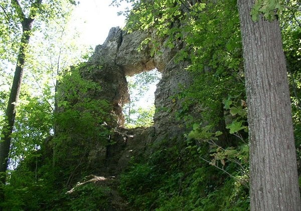
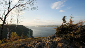
Frontenac State Park – In Yan Teopa Rock
29223 County 28 Blvd., Frontenac, MN 55026
Coordinates: 44.523734° N, -92.342140° W
Park at the picnic area for this hike. The Upper Bluffside Trail takes hikers across a steep 430-foot-high limestone bluff that overlooks Lake Pepin, a natural widening of the Mississippi, to In-Yan-Teopa rock to see this natural limestone arch on the blufftop.
Accessible?: No
Dog Friendly?: Yes
Time to Complete: 2 hours
Distance: 2 Miles (roundtrip)
Difficulty: Moderate/Strenuous
Maintained by: The Minnesota Department of Natural Resources
More Info:
https://www.dnr.state.mn.us/state_parks/park.html?id=spk00160#homepage
https://www.arcgis.com/apps/MapTour/index.html?appid=cb108141401d4e2bbb5b8b1356673ad5
https://conservancy.umn.edu/bitstream/handle/11299/57294/MGS_ES_10.pdf?sequence=1&isAllowed=y
https://gisdata.mn.gov/dataset/geos-karst-feature-inventory-pts
Historic Bluff Country Scenic Byway
Route: Hwy. 16 between La Crescent and Dexter, small loop on US-52 and MN-80 also connects Wykoff and Fountain; a scenic alternative to I-90.
Explore the Karst topography of the Driftless Area by vehicle or bicycle. This 88 mile national scenic byway follows the Root River through deeply carved valleys dominated by towering limestone cliffs. Travel the byway to the Lanesboro Fish Hatchery and other locations within the Discovery Areas.
Any fees?: No, it’s free!
Accessible?: Yes (by car)
Dog Friendly?: Yes
Time to Complete: 4-8 hours
Distance: 88 Miles
More Info:
https://www.dnr.state.mn.us/state_parks/park.html?id=spk00160#homepage
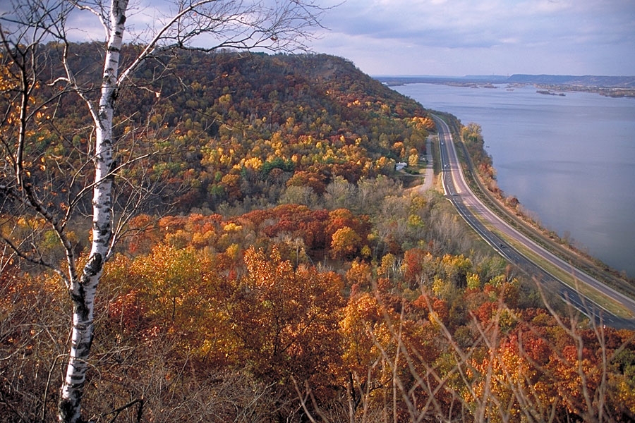
John A. Latsch State Park
Highway 61, Minnesota City, MN 55959
Coordinates: 44.172549° N, -91.838344° W
John A. Latsch State Park is directly off of Hwy. 61, the Great River Road, a few miles north of Winona. Begin your hike at the parking lot, following the signs for the Riverview Trail. This strenuous half-mile hike up to the top of Mount Charity includes 592 stairs, but your reward at the end is worth it. From this vantage point visitors are greeted with a grand long view of the Mississippi River Valley and Driftless Area landscape. Mount Charity is one of three bluffs, Faith and Hope being the other two, which are an extension of a Cambrian and Ordovician aged limestone cap that once extended across the river into Wisconsin. Tremendous volumes of water flowing from regional glacial lakes dissected the valley by way of stream erosion from glacial Mississippi River.
Any fees?: No (State Park Vehicle permit required)
Accessible?: No
Dog Friendly?: Yes (leashed)
Time to Complete: 1 hour
Distance: 0.5 Miles (592 Stairs)
Difficulty: Strenuous
Maintained by: The Minnesota Department of Natural Resources
More Info:
https://www.dnr.state.mn.us/state_parks/park.html?id=spk00160#homepage
https://www.conservancy.umn.edu/bitstream/handle/11299/93782/17-JohnLatch.pdf?sequence=1&isAllowed=y
White Pine Forest Relic
Whitewater State Park, 19041 Highway 74, Altura, MN, 55910
Coordinates: 44.11045621681722° N, -92.17029922416152° W
Although recent glaciers retreated before reaching this region, their meltwaters scoured the many river valleys of the area, leaving behind a landscape entrenched with deep valleys and steep hillsides. Upon close observation of these valleys one will note the different aspect, or exposure, of each bluff face. Upon the south-facing hillsides we find steep, dry prairies, known as goat prairies. These south-facing hillsides are warmer and tend to green up faster in the spring and maintain green vegetation later in the fall. On the north-facing hillsides we observe steep, cool forests which support many relic plant and animal communities able to survive in the cool, shaded forests. On a spring day, you might notice snow blanketing the northern side of a bluff while the southern side is barren of snow and sprinkled with early wildflowers.
One relic plant community of the cooler, north-facing bluffs is the eastern white pine forest. For thousands of years, these pines have survived in small clusters on the cool, rocky north-facing slopes throughout the region. They are drought tolerant and provide important cover for birds and wildlife. These pine forests are characterized by northern species otherwise absent in southeastern Minnesota including balsam fir, yellow birch, Canada yew, nodding wild onion and slender cliff brake.
The land for Carley State Park was donated to the State of Minnesota in 1948 by State Senator James A. Carley and the Ernestina Bolt family in hopes of preserving the outstanding grove of native white pines. In 1957, a severe hailstorm ravaged the trees. Today, white pines tower the steep, rugged valley of the Whitewater River. Park at the Picnic Area lot and walk a couple hundred feet along the river to see pines from below. Or park in the upper lot near the flag pole and hike the trail .15 miles to the observation platform where you can view a stand of pines from across the river.
Any fees?: No (State Park Vehicle permit required)
Accessible?: No
Dog Friendly?: Yes
Time to Complete: 1/2 hour
Distance: 1/3 Mile (roundtrip)
Difficulty: Easy
Maintained by: The Minnesota Department of Natural Resources
More Info:
https://www.dnr.state.mn.us/state_parks/park.htmlid=spk00130#homepage
http://files.dnr.state.mn.us/destinations/state_parks/virtual_tours/carley/vt_carley.html
Great River Road
This section of the Great River Road National Scenic Byway follows the Mississippi River for 39 miles and takes you to John A Latsch State Park and to the Dresbach Welcome Center. The Mississippi River has spent the last 12,000 years carving cliffs into the ancient rocks. These cliffs of soft, white sandstone (called the St. Peter Sandstone) are the lithified remains of the expansive beaches of an Ordovician sea that covered the mid-west 450 million years ago. A look at these sand grains through a magnifying glass reveals sand that has been washed clean and made perfectly round from millions of years of tidal action. Small holes in these cliffs are produced naturally by wind and rain and provide homes for birds. Larger ones were created by people mining the sand for glass bottle production.
The Mississippi River – Lake Pepin watershed consists of forests, bluff lands, and cultivated lands. The top of the watershed is rolling cropland interspersed by many small tributaries that drop steeply through forested valleys with scattered goat prairies atop cliffs. The tributaries join to form the named streams, which drain directly into the Mississippi River. The watershed is only about 50 miles southeast of downtown St. Paul. As a result, the watershed is subject to development pressures.
More Info:
https://www.pca.state.mn.us/water/watersheds/mississippi-river-lake-pepin
https://www.nps.gov/miss/learn/nature/twingeol.htm